LCT Gravity & Magnetics Software

Xcalibur Smart Mapping offers commercial software specializing in gravity and magnetics data processing, interpretation and management.
Create, evaluate, validate
LCT software suite creates simple and complex potential fields models of the earth subsurface, performs forward modeling and joint inversion constrained by gravity and magnetics, seismic and well information – our specialized software helps capitalize potential fields data. Developed in-house by industry-leading potential fields staff, Xcalibur Smart Mapping understands the need for the integration of multiple data sources and the output of results to seismic workflow. Through the intelligent use of data-driven inversions, our focus is on generating geologically reliable solutions to complex geology problems.
The main client base for LCT software suite is large petroleum companies and research institutions, which means LCT software is designed to be integrated into complex exploration workflows and to answer geological questions. LCT software represents a complete package for gravity and magnetic modeling, interpretation, and data processing. These tools are available as single modules or as a combined suite of applications to provide flexible licensing options.
2D Modelling
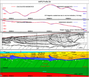
LCT 2MOD lets you conduct 2D and 2.5D gravity and magnetic modeling with or without seismic and other constraints.
Quickly evaluate anomalous geology such as salt bodies, carbonate horizons, volcanic, or understand the depth to basement. 2MOD also models borehole gravity data. 2MOD allows for lateral and vertical varying density definition for modeling geologic cross-sections. The variable density mode adds significant capability to create high-definition density distribution to 2D modeling and is the only commercially available program with this capability.
2MOD provides seamless modeling of integrated seismic, gravity, and magnetics.
3D Modelling
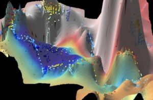
LCT 3MOD helps you understand the geometry of an intrusive (salt, volcanic, etc.) body as well as basin structure and stratigraphy for integration of potential fields and seismic data. 3MOD displays simultaneously the gravity and magnetic model and seismic sections and does both structural and physical property (density or magnetic susceptibility) inversions.
Its joint inversion capability of gravity, gravity gradient, and magnetic data is both very fast and efficient. The 3D modeling suite also contains a fast forward gravity calculation engine from SEGY density data. Several features contained within 3MOD are the only commercially available software with these unique capabilities.
Grid Filtering
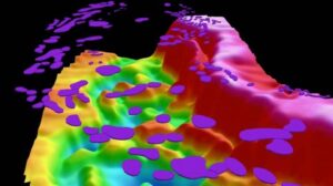
LCT GRDFFT is a complete collection of wavenumber-domain filters (transformations) using the Fast Fourier Transform (FFT). Many current exploration activities are located within the low magnetic latitude zone. Uniquely, GRDFFT implements different algorithms for low latitude magnetic Reduction-To-the-Pole (RTP). For regional studies, GRDFFT also includes the Differential RTP that allows an accurate RTP computation for a large working area.
GRDFFT additionally contains many different spatial-domain filters (transformations). This last advantage is particularly useful when explorationists want to enhance gravity and magnetic signals due to lineaments, edges, and boundaries.
Magnetic Depth Estimation
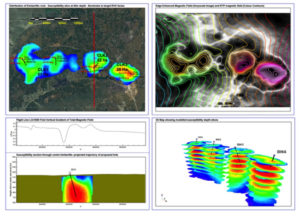
Get the right answers from our magnetic depth modeling software and understand your basement and volcanic intrusions. LCT MAGPROBE is an interactive tool for estimation and comparison of magnetic depths by multiple methods – Werner, Euler, Naudy, SPI, Phillips as well as spectral and empirical methods.
The 3DEULER tool, for the deconvolution of gridded magnetic data and automatic calculation of the depth to the magnetic source, provides you with a quick and easy way to obtain general estimates of the distribution of magnetic sources. It is especially useful when working with large data sets.
LCT DATAPRO is an interactive data processing system for line-oriented gravity and magnetic data and in particular marine (shipborne) data. DATAPRO provides tools for loading gravity and magnetic data into a database, processing the data, and interactively editing and displaying the data. Output from DATAPRO may be imported into LCT’s interactive gravity and magnetics modeling and interpretation software and other industry-standard systems such as ARCGIS. Using the latest advancements in data processing methodology, this marine-oriented processing system enables viewing, processing, systematic adjustments, and correction of data. LCT’s DATAPRO is the only commercially viable system for accurate systematic processing of marine gravity and magnetic data.
More than 100 years of experience
Our staff has more than 100 years of cumulative applied geophysics experience, mostly for various large and smaller mining and petroleum companies and software service providers. This experience is applied to our routine data processing as well as value add data and interpretation services.
Interpretation work ranges from basic first-pass data enhancement and integration, through litho-structural mapping, to more detailed 2.5D and 3D modeling using state-of-the-art software.
In order to optimize the client’s investment Xcalibur provides consultancy services that cover a wide range of methodologies and technologies with the view to maximize the benefit from the survey and properly integrate these data with other geo-scientific data:
- Ground and airborne survey design (magnetic, gravity, radiometric, EM, electrical)
- Ground and airborne survey QA/QC (magnetic, gravity, radiometric, EM, electrical)
- Ground and airborne survey data processing/re-processing (magnetic, radiometric, EM)
- Specialized data processing (magnetic, EM)
- Ground and airborne survey data integration, enhancement and image processing (magnetic, radiometric, gravity, electrical)
- Digital integration of geological, geochemical and geophysical data
- Integrated litho-structural interpretation
- Quantitative geophysical data modeling in 2D and 3D
- Delivery of integrated product on GIS platform
Xcalibur Smart Mapping uses proprietary software to enhance results, quality and add value to existing service offerings:
- Airborne Data Processing Software (ATLAS)
- MagCUBE in Drilling Services
- Commercial software (LCT Potential Fields Software)
- Satellite image processing
- Geographic Information Systems (GIS) for map design
Xcalibur Smart Mapping offers proprietary software specializing in data processing, interpretation and management:
- LCT Potential Fields Software
- Proprietary software for the Oil & Gas industry (XFIELD & GPROC)
- Satellite image processing
- Geographic Information Systems (GIS) for map design