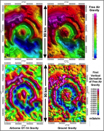
Airborne Scalar Gravity (ASG)

Scalar gravity measurements have a wide range of applications, including regional geological mapping, sedimentary basin investigation for Oil & Gas, and geodetic studies.
Scalar Airborne Gravity
Gravity data is used alone or in combination with other datasets to identify the location and size of the major source structures containing accumulations of hydrocarbons, massive base metal deposits, iron ore, salt domes, and hydrogeological aquifers.
Xcalibur Smart Mapping acquires airborne scalar gravity either as a primary acquired dataset or as a valuable additional dataset in conjunction with AEM, AGG, or Magnetic surveys.
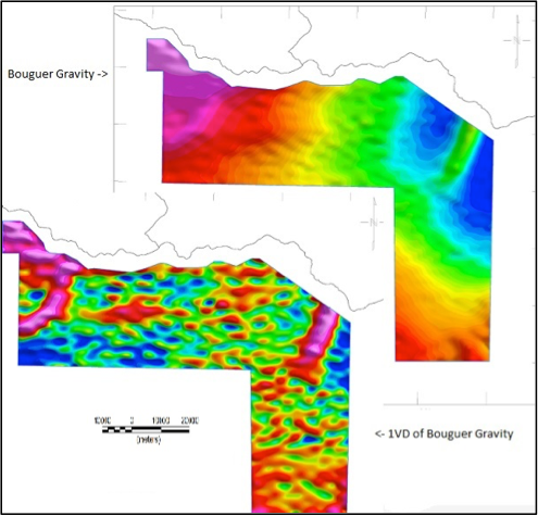
iCORUS-X Scalar Airborne Gravimeter
The iCORUS-X is a unique scalar gravimeter that acquires gravity data without the stabilized platform required by conventional airborne gravimeters. The iCORUS-X is exclusive to Xcalibur Smart Mapping and delivers data at half the noise levels of commercially available systems. It has evolved from the successful sGRAV gravimeter and has significantly enhanced performance and data quality.
The iCORUS-X is compact and is very robust to air turbulence experienced during surveys. This allows Xcalibur to acquire high quality scalar gravity data simultaneously with magnetic, electromagnetic or gravity gradiometry surveys, even under turbulent and dynamic drape conditions, without impacting on the primary technology survey.
When used at wider line spacings (1km or more), the iCORUS-X acquires gravity data quality of <1.0mGal at a half-wavelength resolution of 3km.