Airborne Electromagnetics (AEM)

Electromagnetic surveys are primary airborne techniques for 3D conductivity mapping of the sub-surface. Including mineral exploration, geothermal and new energy sources, groundwater, geohazards, geotechnical and environmental engineering, and others.
Xcalibur Smart Mapping is proud to offer a full suite of industry-leading airborne electromagnetic technologies, each one the best in their class. Our AEM systems are designed specifically for different applications, which allows us to provide the best technical and commercial solution to your geoscience challenge. No system is best for all applications.
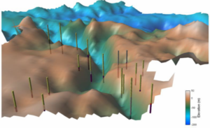
Different Xcalibur AEM technologies are used to image targets at surface, or to depths in excess of 600 ground meters (* realized depth dependent on ground conductivity) and from small targets less than 10 meters in size to vast mapping programs covering entire countries.
All our AEM systems simultaneously acquire electromagnetic and magnetic data and can optionally acquire radiometric and scalar gravity data; delivering up to four complementary datasets from one survey, greatly increase the interpretability and applicability of the survey data.
All our AEM systems are proprietary to Xcalibur Smart Mapping and are the product of decades of research and development, continual improvement, extensive survey experience, and client interaction. We look forward to deploying one of them on your project.
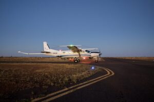
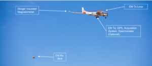
TEMPEST®
TEMPEST® is the world’s leading fixed-wing airborne electromagnetic system and was designed specifically to acquire high resolution, broad-bandwidth, and fully calibrated AEM data which can be used quantitatively for both mapping applications and direct detection of conductive targets.
TEMPEST’s uniquely broad bandwidth allows resolution of both subtle and large variations in conductivity from the surface to +500m depth (actual depth of investigation varies with earth conductivity), making it the best system for high-resolution mapping of both deep and shallow targets.
TEMPEST® is unique in that its system geometry is fully measured and used to fully calibrate the AEM data. Fully calibrated data allows more accurate inversions that more precisely image map geology and discrete conductive targets.
TEMPEST® is installed on a Cessna 208B Supervan 900 turbine aircraft, a highly efficient platform for fast and cost-effective acquisition of detailed conductivity data. The fixed-wing configuration allows the aircraft to be based in established airports and fly long distances to collect data, eliminating the need for ground access within the survey area. This removes the need to establish remote base camps, minimizes social and environmental impact and access issues, and ensures high production rates.
TEMPEST® is an airborne system of choice for Government and private groups worldwide.
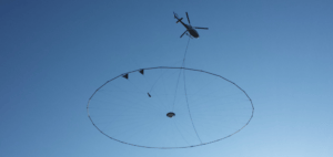
HELITEM²®
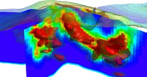
HELITEM²® helicopter time-domain AEM provides high-resolution earth conductivity imaging with maximum exploration depth (up to 800m depending on ground conductivity) and enhanced sensitivity to conductive targets.
HELITEM²® uniquely acquires Tx frequencies as low as 6.25Hz, using a high-power square wave form for enhanced shallow resolution, a wide Tx pulse width for greater target energisation, and long Tx off times for imaging deep and conductive targets.
HELITEM²® images conductive targets in higher resolution, and to greater depths than competitor systems.
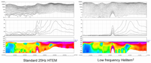
Low-frequency HELITEM²® data compared to standard 25Hz helicopter time-domain data over a massive sulphide target. The target response is stronger, the noise levels are lower, and the depth of exploration is greater, especially in the more conductive geology to the right.
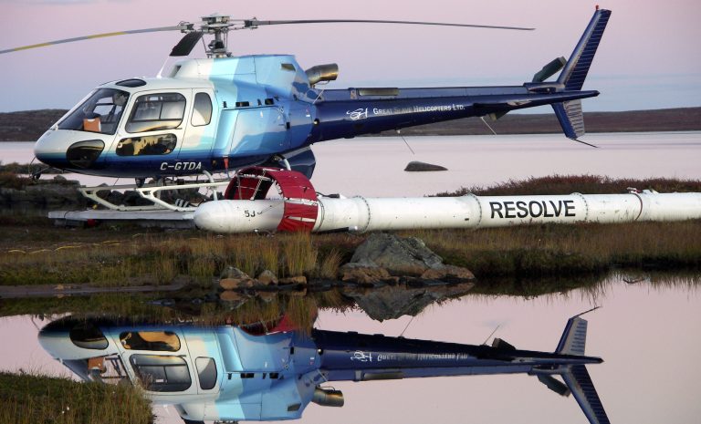
RESOLVE®
RESOLVE® helicopter frequency-domain AEM systems provide the highest resolution and sensitivity of any airborne electromagnetic systems on the market, giving you the very best in near-surface conductivity measurements.
RESOLVE® systems are light and aerodynamic, allowing them to closely drape terrain for maximum sensitivity and resolution. They are the AEM system of choice in mountainous terrain where heavier time-domain systems cannot maintain survey height.
RESOLVE® is available in a choice of coil configurations, each suitable for a wide range of applications.
RESOLVE 6 uses a six-frequency coil array providing the broadest range of frequencies, sensitivity to the broadest range of resistivity values, and unparalleled horizontal and vertical resolution of any AEM system. RESOLVE 6 is designed specifically to provide the level of precision, repeatability and reliability required for demanding mapping applications.
RESOLVE 5 (previously called DIGHEM) uses a large separation five frequency coil array and is used for a wide range of applications and has contributed to the discovery of many commercial ore bodies. A wide frequency range and multi-coil geometry assure the best possible sensitivity to geologic targets, depth of penetration, and distinct anomaly shapes over vertical vs. flat-lying conductive bodies permitting determination of target orientation and dip.