Underground Storage of CO2
Geological Storage of CO2
The exploration of CO2 storage is crucial in addressing the urgent challenge of carbon dioxide emissions and their impact on global climate change. At Xcalibur Smart Mapping, we recognize the urgent need to mitigate the consequences of CO2 emissions, as highlighted by the Intergovernmental panel on Climate Change. Our focus extends beyond transitioning to renewable energy sources, encompassing solutions like carbon capture usage and storage (CCUS) and the preservation and enhancement of natural CO2 sinks.
These strategies not only offer avenues for climate mitigation but also hold significance in shaping the future decarbonized economy. With our commitment to innovative CO2 storage technologies and solutions, we strive to lead the way towards a sustainable future.
Underground Storage of CO2
Storing CO2 underground is part of the suite of technologies in carbon capture usage and storage (CCUS) which involves capturing CO2 emitted from industrial processes or power generation sources and injecting it deep underground into suitable geological formations. This way, large volumes of CO2 can be stored securely over long periods, preventing the CO2 from being release back into the atmosphere. Suitable storage formations include depleted oil and gas reservoirs, saline aquifers, coal seams, organic-rich shales and basaltic or ultramafic rocks. Each storage type is different, and CO2 can be either physically trapped within the pore spaces of the rock, dissolved into water, or chemically trapped by being adsorbed (or adhered) or by reacting to form stable carbonate mineral, achieving permanent storage.
The CO2 storage characterization/assessment methodology requires data collection, 3D static geological modelling, dynamic modelling, sensitivity characterization and risk assessment. Hydrogeological, geological, and geophysical data must be integrated to map the geological structure and to perform the 3D static geological modelling (Bergmo, P.E.S., et al, 2016. Quality ranking of the best CO2 storage aquifers in the Nordic countries).
The phases for carbon storage subsurface development includes the regional screening, capacity evaluation, storage de-risking, site integrity, and monitoring (CGG Industry Application/Energy Transition/CCUS Subsurface Development).
The first phase consists in performing a regional screening to identify the best prospective CO2 subsurface storage sites, assessing depleted oil & gas fields for enhanced oil recovery (EOR), and CO2 storage in deep saline aquifers and onshore shallow reservoirs. Basin type, tectonic/structural setting (faults system, fractures), reservoir lithology, depth, thickness are the geological criteria for the regional screening and site selection. As in oil and gas exploration, Xcalibur’s high-resolution gravity gradient and magnetics (Falcon airborne gravity gradiometry – AGG) and airborne electromagnetic (AEM) as TDEM systems (TEMPEST® and HELITEM®) can be integrated with other geophysical and geological data to support the calculation of these key parameters.
The second phase deals with the evaluation of the CO2 storage capacity using existing reservoirs models to better understand the performance and uncertainty of the rock-fluids interaction, relating CO2 injection and storage. Containment of a storage site is evaluated based on seal capacity, characteristics of cap rocks, faults and fractures surrounding the reservoir. The reservoir properties are thickness, spatial distribution (e.g., depth, extension), porosity and permeability distributions, hydraulic continuity between reservoirs. FALCON® AGG can be used for lithologies and faults mapping, contributing to the determination of the reservoir properties, while and airborne TDEM systems (TEMPEST® and HELITEM®) are fundamental to obtain conductivity data for the determination of the aquifer’s salinity.
The third phase involves the de-risking storage management by modelling the CO2 displacement and injection plumes, analysing injection rates, and optimizing the CO2 injection development plans. This phase is focused on structural framework to de-risk fluids migration and vertical leaking. Falcon AGG is potentially a cost-effective and complementary technology when faults and fractures are not well-imaged from the available seismic data.
In the fourth phase, the building of a 3D geo-mechanical model assures the subsurface site integrity for safe and responsible storage management. Pore pressure prediction and trap & seal analysis are crucial.
The last and fifth is the implementation of solutions for monitoring the injected CO2, including its migration, growth, and escape. This phase is engaged on detection and prediction of CO2 migration and leakage paths over time. Multiphysics interpretation of 4D seismic, gravity, electromagnetic data are essential to be integrated in the geological interpretation for fluid imaging. Airborne electromagnetic systems as RESOLVE®, TEMPEST® and HELITEM® could be used for modelling shallow reservoir resistivity changes in the onshore.
In addition, in the case of CO2 storage in depleted oil and gas fields, orphaned (or abandoned) wells pose a high risk as they will serve as leak paths, releasing the CO2 back into the atmosphere. Locating these wells, so they can be plugged, is an essential yet difficult task that can be tackled with Xcalibur’s ultra-high resolution magnetic systems (Midas®).
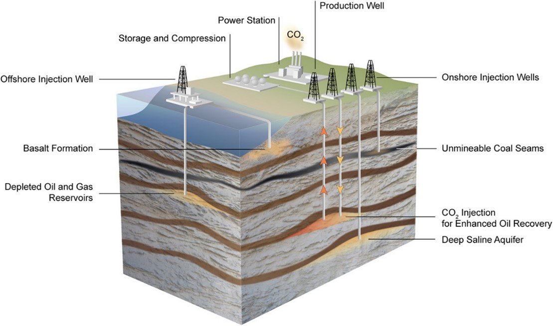
Source: Yang, Q., Yu, Y., Zhang, Y., Shi, Y., Zhang, B., & Liu, G. (2023). Recent advances in carbon dioxide geological storage, experimental procedures, influencing parameters, and future outlook. Journal of Environmental Sciences, 101, 123-135.

